Showing posts with label Year 9. Show all posts
Showing posts with label Year 9. Show all posts
Monday, 1 June 2009
Jane and Joe do Volcanoes
Thanks GeoDave from the SLN for sharing that with us. I'm sure pupils will find it very useful.

Thursday, 28 May 2009
Tsunami Alert Called Off

A tsunami watch in place for three Central American countries after a 7.1 magnitude quake struck off Honduras has been called off.
The Pacific Tsunami Warning Center said the danger of a tsunami hitting Belize, Guatemala and Honduras had now passed.
The powerful quake hit 64km (39 miles) north-east of Roatan on Honduras' Isles de la Bahia in the Caribbean Sea, the US Geological Survey (USGS) said.
There were no immediate reports of major damage or mass casualties.
The quake struck at 0324 local time (0824 GMT) at a relatively shallow depth of 10km(six miles).
Tremors were felt in dozens of cities across the region and as far north as Cancun in Mexico, the USGS said.
People in Guatemala City ran into the streets in their pyjamas, the Associated Press news agency reports.
The Pacific Warning Center in Hawaii said that the danger of a major tsunami wave hitting the coastlines of nearby countries had now passed.
But it warned that boats and coastal structures could still be affected by rapid currents caused by the quake.
Tuesday, 7 April 2009
Italian Earthquake


At least 90 people are believed dead and tens of thousands homeless after an earthquake hit L'Aquila and other towns in central Italy, rescuers say.
About 1,500 people were injured and many people are still missing as rescuers search desperately for survivors trapped beneath rubble.
The 6.3-magnitude quake struck at 0330 (0130 GMT) close to L'Aquila.

Click here for the full BBC news report and video footage

It is also interesting that suggestions say this earthquake was predicted yet the warnings were ignored. Click here to find out more.
Saturday, 28 March 2009
Mount St Helens and Pyroclastic Flows
An excellent video from the BBC explaining how pyroclastic flows actually kill people and it also includes real time footage of the Mount St Helen's eruption of 1980. An excellent video providing further information on a popular case study.
Saturday, 21 March 2009
Volcanic Eruptions in Tonga

An undersea volcano is erupting in the Tonga islands, shooting clouds of volcanic smoke, steam, and ash thousands of feet into the sky above the South Pacific ocean.
Authorities said Thursday the volcanic eruption does not pose any danger to Tonga islanders at this stage, and there have been no reports of fish or other animals being affected.
Spectacular columns are spewing out of the sea about 6 miles from Tonga's main island of Tongatapu—an area where up to 36 undersea volcanoes are clustered, geologists said.
Trade winds continued to blow volcanic gas and steam away from the island Thursday.
Taniela Faletau, deputy commander of the Tonga police force, said coastal villages close to the roiling ocean site were not yet at risk from the volcanic eruption. No warnings have been issued.
Coastal residents said the volcanic steam and ash column first appeared on Monday morning, after a series of sharp earthquakes were felt in Tonga's capital, Nuku'alofa.
The underwater volcanic eruption was taking place near the low-lying twin volcanic islands of Hunga Tonga and Hunga Ha'apai, within sight of Nuku'alofa.
Large amounts of pumice thrown up by the volcanic eruption would likely clog beaches on the southern coast of the nearby Fiji Islands within a short time, Mafi said.
Tonga, a 170-island archipelago about halfway between Australia and Tahiti, is part of the Pacific Ring of Fire—an arc of earthquake and volcanic zones stretching from Chile in South America through Alaska and down through Vanuatu to Tonga.
Wednesday, 11 February 2009
Kung Fu Plate Boundaries
A very alternative way of looking at the tectonic plate boundaries.
With thanks to Odblogs and Adam Brewer (and Jo Blackmore for bringing it to my attention)
With thanks to Odblogs and Adam Brewer (and Jo Blackmore for bringing it to my attention)
Rainforest Assessment

Year 9 pupils are currently completing their rainforest assessment where they have to produce a booklet on the rainforest.
Suggested content includes:
• Where are the rainforests?
• What are rainforests and its inhabitants like?
• What is the climate like in the rainforest?
• Why are rainforests shrinking?
• What are the consequences of deforestation?
• How can the rate of deforestation be reduced?/How can rainforests be used sustainably?
The front cover must be in poster format.
It needs to be presented in either A4 or A5 format with at between 3 - 5 sides of text (Font size: no bigger than size 14).
Use websites such as:
Save the Rainforest
The rainforest Foundation
Rainforest Web
The Rainforest Alliance
World Wildlife Fund
Blue Planet Biomes
Enchanted Learning

Sunday, 18 January 2009
Sunday, 30 November 2008
Amazon Deforestation Accelerates
 The destruction of the Amazon rainforest in Brazil has accelerated for the first time in four years, Brazilian officials say.
Satellite images show 11,968 sq km of land was cleared in the year to July, nearly 4% higher than the year before.
Mount St Helen's Song
With thanks to Joanna Blackmore for bringing this video to my attention. Not only is it educational but it is a bit of fun as well. Enjoy boys and girls!
Sunday, 23 November 2008
Amazon Rainforest
Watch this video and consider your 5 senses:
- What would you be able to see in the rainforest?
- What would you be able to hear in the rainforest?
- What would you be able to touch in the rainforest?
- What would you be able to smell in the rainforest?
- What would you be able to taste in the rainforest?
Friday, 7 November 2008
Coral Reefs Under Threat From Climate Change
 The following link provides you with excellent information on the impact of climate change on coral reefs. These are very sensitive ecosystems and as a result of climate change, are under great threat.
Climate change therefore needs to be addressed before irreversible damage is done to this ecosystem and others.
The Great Californian Shake Out

At 10 a.m. on November 13, join millions of people throughout Southern California in the Shake Out Drill, the largest earthquake preparedness activity in U.S. history!
The Great Southern California Shake Out includes the ShakeOut Drill and other events to help us get ready for big earthquakes.
It is promoting the concept of "Drop Cover Hold"
 Why is important to do a Drop, Cover, Hold On drill?
Just as with anything, to act quickly you must practice, practice, practice. In a big earthquake, there may be very little time to protect yourself before strong shaking knocks you down or drops something on you. Most earthquakes have a sharp jolt a few seconds before the strong shaking, and we need to Drop, Cover, Hold On immediately when we feel the jolt. By practicing we will act quickly, rather than waiting to see if the earthquake will be large. If it is, it may be too late to protect yourself. ShakeOut. Don't FreakOut.

On July 29th 2008, magnitude 5.4 earthquake that shook southern California. This caused a huge amount of damage. However, the Great Californian Shake Out is a means of preparing people for a magnitude 7.8 earthquake, which is 5000 times larger than that in July.
As a result, the amount of damage will be much greater. The ShakeOut Scenario estimates that an earthquake of magnitude 7.8 would cause some 2,000 deaths, 50,000 injuries, $200 billion in damage and other losses, and severe, long-lasting disruption.
Fantastic video on the potential of a magnitude 7.8 earthquake below.
It's not a matter of if an earthquake of this size will happen-but when. It is possible that it will happen in our lifetime.
Red Hot Chile's Smoking Volcano
Mount Chaiten is looking set to blow its top....

The Chilean volcano showed new signs of activity in the recent days and so residents are having to prepare for the potential eruption.

At the time there were fears that Mt Chaiten would continue to release ash into the atmosphere for months (See video). As a result, a huge area around the volcano had to be evacuated but ash was carried by the wind across large parts of South America, prompting fears of a major health crisis.
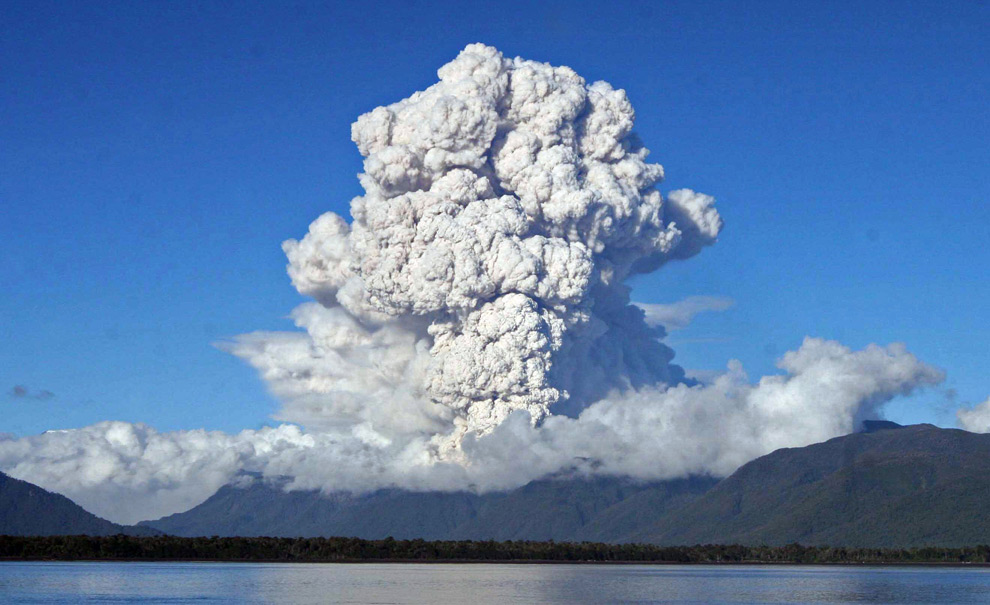
The Chilean volcano showed new signs of activity in the recent days and so residents are having to prepare for the potential eruption.
Click here to see video footage from a plane showing the newly ruptured dome.
Back in January 2008 and again in May 2008, the volcano was showing signs of an eruption. The image below is one taken during an electric storm.
At the time there were fears that Mt Chaiten would continue to release ash into the atmosphere for months (See video). As a result, a huge area around the volcano had to be evacuated but ash was carried by the wind across large parts of South America, prompting fears of a major health crisis.
Monday, 3 November 2008
Japan Assignment
 Pupils in Year 9 are expected to produce an annotated poster describing and explaining the different physical and human geographical features of Japan for their first major assessment of the year.
- You must produce an A3 poster that has a central map locating the major physical and human geographic features of Japan (Cities, Transport Networks, Islands, Rivers, Mountains, Seas/Oceans, )
- The map must include a key and compass point
- In and around the map, you must write annotations describing the various regions (Include information on climate, soils, relief, industry, famous landmarks, culture etc)
- You must also include pictures of the different things discussed in your annotations e.g a photo of Mt Fiji or the Bullet train
 Remember that you will be levelled for this piece of work so it is important to invest the time and effort. If you need any help it is important to come and see me or your class teacher as soon as possible.
The following sited might help you complete this task:
Subscribe to:
Posts (Atom)


 Posts
Posts


